Wednesday, September 13, 2023

Little Outhouse on the Prairie. Walker Jenkins Lake

These are the facilities at Walker Jenkins Lake, a fishing hole that was, originally, an open pit Uranium Mine.


We'll let you ponder that for a second.


 Fairly typical rural facilities for Wyoming, and a nice example.

Friday, April 21, 2023

State of Wyoming Rest Stop: Shirley Rim Rest Area.

I should really have started this blog with this entry, as more than any other Wyoming rest stop, it's the one I've stopped at the most.

The Shirley Rim Rest Area.

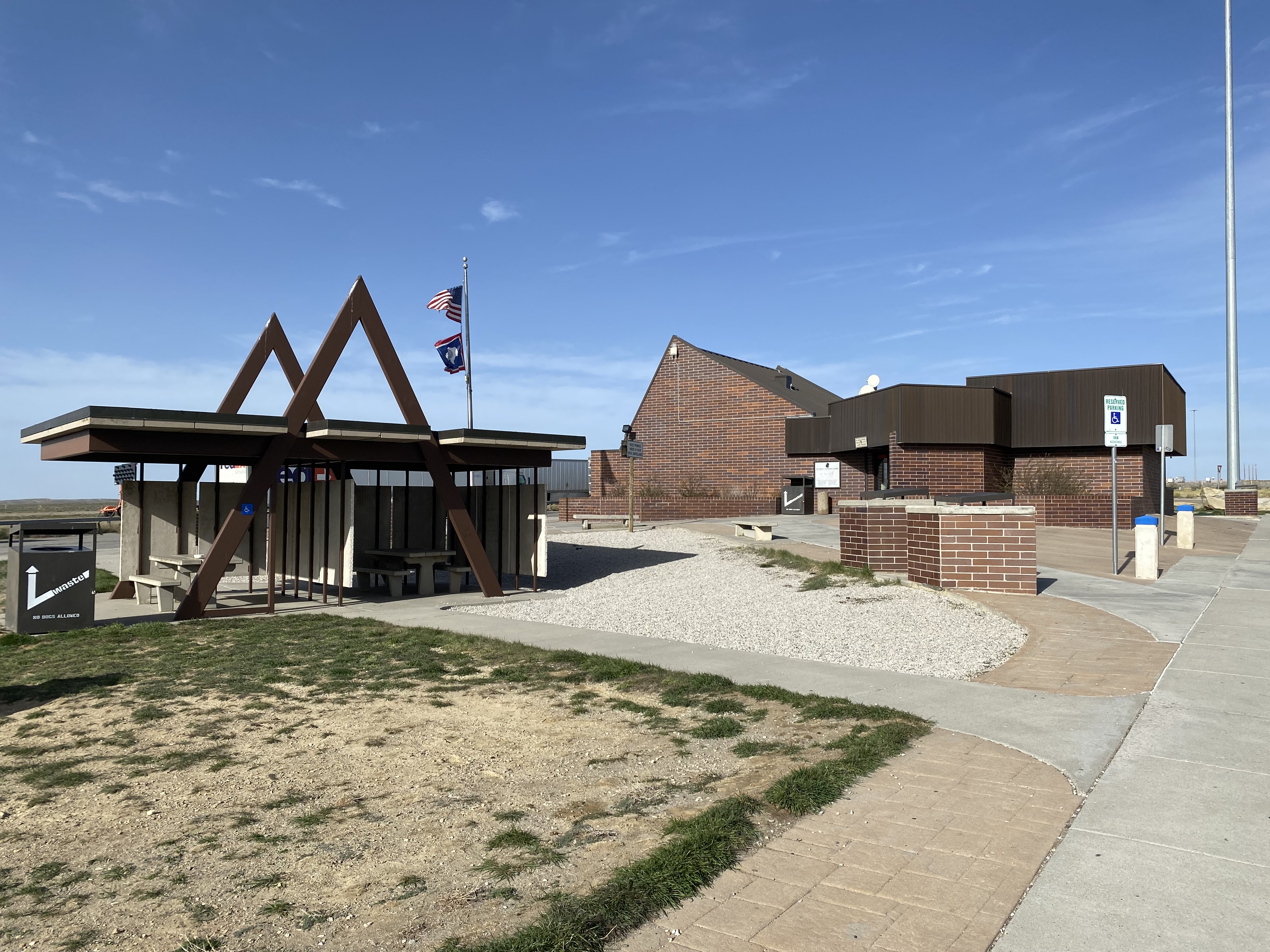
An archetypical example of the Wyoming solar rest stop, this station is located near Mile Marker 45 on Highway 487, just after, or before, the spot where the highway junction with the old Highway 77 is located.  It's located on the Casper side of Shirley Rim, on the road to Medicine Bow.


Resident of the rest area.

Because of its location, it's a heavily used rest station, as it's on the route to, or from, Laramie.  Having said that, its location is, in my view, a bit badly placed, as It's quite near Casper, if traveling in towards Laramie, or Saratoga, and quite far from those locations if traveling in the other direction.  Frankly, locating it near or in the town of Medicine Bow would have made more sense.  Indeed, in the summer months, if I need to stop, I'll actually tend to stop at the baseball fields in Medicine Bow, which have facilities, or in Rock River, which isn't far down the road.


It's a small, but typical, rest area of this type.  The Wyoming Wildlife sign has suffered from the elements heavily over the years, and the weather in this area is frequently bad.  Isolated when first built, and largely still pretty isolated, a small village now exists across the highway from it, housing Wyoming Department of Transportation crews who keep the highways open, or try to.

In that sense, this is one of the more rustic, in terms of atmosphere, Wyoming rest areas.  It has picnic benches and the like, but I never see them actually used.  It's old enough that I can recall it having a pay phone, and there was an area rancher who had never had a phone put in at his headquarters as late as the 1990s, who used the phone at the station if he needed to.

Wednesday, July 27, 2022

State of Wyoming Rest Stop, Sheridan Wyoming.


One of the nicest of the WTDOT rest stops, it has a great geologic and archeological display inside, and attendants who have tourist information.  It's clean, and hte back side of it has a commanding view of the City of Sheridan.


Tuesday, June 14, 2022

State of Wyoming Rest Stops, Interstate 80, between Wamsutter and Rock Springs, Wyoming.

This actually depicts two WYDOT rest stops, the two probably being the two busiest in the state.  They're on a long stretch of Interstate 80.  Offhand, I think these are the first rest stops, going west, since the one at Ft. Fred Steele.


That's a long ways.

This is two, not one, rest stops, as the highway is divided.  The two rest stops are likely 1/4 mile distant from each other, on opposite sides of the highway.


They aren't in a scenic location, which no doubt is besides the point. Dedicated to the Dwight D. Eisenhower Highway, they're on part of the path of the old Lincoln Highway and near the Union Pacific Railroad's location.  In some ways, they're the closest thing a modern traveler will experience to the old stage stop.  No food, of course, but a place to briefly stop in the middle, more or less, of Wyoming's Red Desert.

Indeed, on the day I took these photos, a traveler from out of state was taking his horses out of his horse trailer for a break.

Tuesday, February 1, 2022

Lex Anteinternet: Lincoln Highway Redux?

Lex Anteinternet: Lincoln Highway Redux?

Lincoln Highway Redux?

Gen. Luke Reiner[1] head of the Wyoming Department of Transportation, has stated that WYDOT is proposing to reroute Interstate 80 along the path of Wyoming Highway 30.

Eh?

Okay, this is the stretch between Laramie and Rawlins, which is notoriously bad during bad weather.  For those not familiar with I80 in that area, or Highway 30 between Laramie and Rawlins, observe below:

WYDOT Public use map.

For those who are historically mineded, you may be thinking that Highway 30, in taht area, looks a bit familiar.

That's because that is where the "interstate", or prointerstate if you will, was prior to Interstate 80 being build.

Witness:


Gen. Reiner notes, in his statements to the Cowboy State Daily, that 
“If you look at a map, you’ll see that the old highway, Highway 30, goes further to the north, and then sort of comes down from the north into I-80.  Rumor has it that when they went to build I-80, that the initial route followed the route of Highway 30. And somebody made the decision, ‘No, we’re going to move closer to these very beautiful mountains,’ to which the locals said, ‘Bad idea,’ based on weather. And it has proved to be true.”
I don't know if its a rumor, a nd I don't know if they had beuty in mind.  I've heard the same thing about locals warning those building the highway not to get to close to the mountains, only to be disregarded.

Highway 30 followed the route of the Union Pacific, and except in this stretch still largey does.  The Interstate, however, followed a cutoff route of the Overland Trail.  Taht's signficantin that the portion of the Overland Trail that it followed turned out to be an unpopular one, and the Army, which garrisoned a post at the base of Elk Mountain, eventually abaonded it.

We've writtein about that location here:

Sunday, August 2, 2020

Ft. Halleck, sort of. Near Elk Mountain Wyoming

Where Ft. Halleck was, from a great distance.

This set of photographs attempts to record something from a very great distance, and with the improper lenses.   I really should have known better, quite frankly, and forgot to bring the lense that would have been ideal.  None the less, looking straight up the center of this photograph, you'll see where Ft. Halleck once was.


The post was located at the base of Elk Mountain on the Overland Trail, that "shortcut" alternative to the Oregon Trail that shaved miles, at the expense of convenience and risk.  Ft. Halleck was built in 1862 to reduce the risk.  Whomever located the post must have done so in the summer, as placing a post on this location would seem, almost by definition, to express a degree of ignorance as to what the winters here are like.

 The area to the northeast of where Ft. Halleck once was.

The fort was only occupied until 1866, although it was a major post during that time.  Ft. Sanders, outside the present city of Laramie, made the unnecessary and to add to that, Sanders was in a more livable 


Of course, by that time the Union Pacific was also progressing through the area, and that would soon render the Overland Trail obsolete.  While not on an identical path the Overland Trail and the Union Pacific approximated each others routes and, very shortly, troops would be able to travel by rail.


As that occured, it would also be the case that guarding the railroad would become a more important function for the Army, and forts soon came to be placed on it.

Elk Mountain

And, therefore, Ft. Halleck was abandoned.


Whatever the reason for locating Interstate 80 there, and I suspect it had more to do with bypassing a bunch of country, making the road shorter, and the like, it was a poor choice indeed. The weather in that area is horrific during the winter.  Perhaps the irony of that is that this stretch of the National Defense Highway system would have had to end up being avoided, quite frequently, if we'd really needed it if the Soviets had attacked us in the winter.  

Gen. Reiner, who really doesn't expect this to occur, has noted in favor of it:
Our suggestion to the federal government is to say, ‘If you want to do something for the nation’s commerce along I-80, reroute it. Follow Highway 30 — it’s about 100 miles of new interstate, the estimated cost would be about $6 billion. So, it’s not cheap, but our estimate is that it would dramatically reduce the number of days the interstate’s closed, because that’s the section that that kills us.
It doesn't just "kill" us in a budgetary fashion. It kills a lot of people too.  Anyone who has litigated in Wyoming has dealt with I80 highway fatalities in this section.  That makes the $6,000,000,000 investment worthwhile in my mind.

And of course taking the more southerly route doesn't just kill people, as crass as that is to say, it helped kill the towns of Rock River and Medicine Bow, two of the five towns on that stretch of Highway 30 that were once pretty bustling Lincoln Highway towns.[1]   Highway 30 runs rough through them.  

And of note, FWIW, Highway 30 between Bosler and Rock River

Now, I know that a new Interstate 80 wouldn't go right through Rock River and Medicine Bow, but past them, like Highway 30 does to Hanna, but some people would in fact pull off.  It's inevitable.  

It's a good idea.

Not as good of idea as electrifying the railroad and restoring train travel, but still a good idea.

It won't happen, however.  Not even though there's still relatively little between Laramie and Rawlins, and it won't cause any real towns to dry up and blow away.  Not even though it would save lives and ultimately thousands of lost travel dollars.  And not even though the current administration is spending infrastructure money like crazy.

Footnotes:

1.  Before he was head of WYDOT, Reiner was the commanding officer of the Wyoming Army National Guard.

When I was a National Guardsmen he was a lieutenant, and his first assignment was to my Liaison section.  I knew him at that time.  He's an accountant by training, and he was in fact an accountant at the time.  His parents were Lutheran missionaries in Namibia, where he had partially grown up.

2.  The towns are Bosler, Rock River, Medicine Bow,  and Hanna.

Thursday, November 18, 2021

Wright Wyoming Rest Stop

Some Gave All: Veterans' Memorial, Wright Wyoming:     

Veterans' Memorial, Wright Wyoming

 All wars memorial in Wright, Wyoming, at the town's park just off the highway.


 The bricks feature the names of servicemen from Wright who lost their lives in the service.


Thursday, May 6, 2021

Reopening of the Rest Stops


Governor Gordon Authorizes Funding to Temporarily Reopen 9 Rest Areas for the Summer Travel Season


CHEYENNE, Wyo. –  Governor Mark Gordon has directed the Wyoming Department of Transportation (WYDOT) and Wyoming Office of Tourism (WOT) to partner to temporarily reopen and operate nine previously closed rest areas for at least the duration of the 2021 tourist season.

“With the summer season just around the corner, I’m glad we will be able to reopen these facilities to travelers,” Governor Gordon said. “We are glad to have this chance to find a temporary solution.”

WYDOT and WOT along with the Governor's office will work together to secure a temporary federal funding source to allow the nine rest areas throughout the state to reopen. 

"WYDOT is extremely grateful to Governor Gordon and Director Shober for identifying new federal funds to temporarily reopen our rest areas for the tourist season," said WYDOT Director K. Luke Reiner. 

Officials closed the rest areas in June 2020 as a cost-savings measure due to budgetary shortfalls. 

 The nine rest areas include:

  • Lusk on US 18
  • Guernsey on US 26
  • Greybull on US 16
  • Moorcroft on I-90
  • Star Valley on US 89
  • Sundance on I-25
  • Upton on US 16
  • Orin Jct on I-25
  • Chugwater on I-25

“Each of these nine rest areas are a valuable tourism tool, said Diane Shober, executive director of the Wyoming Office of Tourism. “Certainly, a clean facility is important to the visitor experience, but it is also a powerful marketing platform to distribute travel guides and other trip-planning resources. As travelers are stretching their legs, they are also gathering information on local events, attractions, restaurants, campgrounds and lodging, which all can lead to extended stays and increase visitor spending.”

The rest areas should reopen ahead of Memorial Day weekend.

-END-

Little Outhouse on the Prairie. Walker Jenkins Lake

These are the facilities at Walker Jenkins Lake, a fishing hole that was, originally, an open pit Uranium Mine. We'll let you ponder tha...